June 24, 2025
Exceptionally Wet Weather Conditions Lead to Delayed Planting in New York
By: Chris Laughton

While corn and soybean crop planting is slightly ahead of last year nationally, it is way behind in New York and across the Northeast, due to unusually cold and wet weather, making field work difficult.
USDA Crop Progress -18 survey states:
|
% Planted |
As-of: June 8 |
Previous Week |
Previous Year |
|
National Corn |
97% |
93% |
94% |
|
National Soybeans |
90% |
84% |
86% |
|
NY Corn |
51% |
33% |
79% |
|
NY Soybeans |
41% |
21% |
68% |
~ USDA NASS
For an in-depth analysis of the recent weather patterns we have seen in the region, please see the information below provided by Jessica Spaccio and Samantha Borisoff at the Northeast Regional Climate Center at Cornell University.
May wrapped up on the wet side of normal for almost the entire state. Albany, NY, had 218% of its normal precipitation, ranking as the third wettest May on record. Albany had its wettest May 9, with 1.92” of rain, and wettest May 31, with 1.67” of rain.

Many stations had precipitation that ranked in their top 10 wettest. For instance, Auburn, NY, had 7.14” and was their wettest May on record based on 105 years of data. (credit to Southeast RCC Climate Perspectives Tool)

Some stations also had the greatest number of May days with at least an inch of rain. For example, Little Valley, NY, had three such days which was the most in their 77 years of history.

The first half of May was unusually warm, but the second half was much cooler. This allowed May to average out to be within 2°F of normal for most locations. Binghamton tied a record for the coldest May 21, with a high of only 49 degrees F.


In early May, central New York experienced damaging straight-line winds of up to 85 mph. Heavy rain resulted in flash flooding in eastern New York where rain totals generally topped out around 5 inches. A microburst caused severe damage in Monterey of Schuyler County on May 2.
May’s exceptional wetness overpowered the variable precipitation amounts in March and April for many locations. Albany, NY, had 137% of normal precipitation for the spring season.

Both March and April temperatures averaged out to be warmer than normal for most areas, and along with the mild start to May, were enough to push spring average temperatures to above normal in the Northeast.

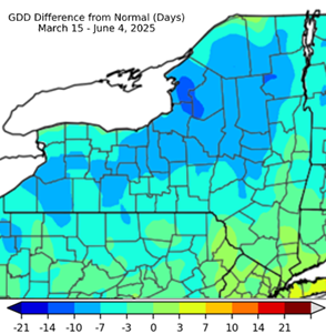
However, cooler daily temperatures have led to growing degree days being a week to ten days behind for some areas of New York.
Last week (June 17-23) the majority of the state experienced slightly above-normal precipitation and and temperatures.
NOAA’s Climate Prediction Center (CPC) 8-14 day outlook for the entire month of June favors equal chances for precipitation probabilities, meaning equal chances of above-normal, below-normal, or near-normal precipitation. The outlook favors above-normal temperature with a 50-60% probability.

What’s in store for the remainder of the growing season?
NOAA’s Climate Prediction Center (CPC) 8-14 day outlook for the summer season (June, July, August) slightly favors above-normal precipitation and above-normal temperatures.

NOAA’s National Hurricane Center outlook for the 2025 Atlantic hurricane season favors an above-normal season with 13-19 named storms, 6-10 hurricanes, and 3-5 major hurricanes. There are currently no disturbances in the Atlantic. Outlooks do not forecast landfall or locations, but it is something to watch after a wet spring.


Director of Knowledge Exchange
- Share this post on


